Description
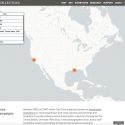
The Digital Art History Lab and the Center for Advanced Research of Spatial Information(link is external) at Hunter College, CUNY, are collaborating on an online, interactive tool that uses Geographic Information Systems (GIS) technologies to document the movement of Frick Art Reference Library photographers across the United States as they recorded paintings and sculptures in private collections and little-known public collections. Several such expeditions were completed between 1922 and 1967. The resulting 35,000 negatives from these photograph campaigns, all of which have been digitized, are one of the most valuable resources in the Photoarchive, documenting many objects that either remain inaccessible to the general public or have been lost, destroyed, or altered in the intervening decades.
The first phase of the development of this tool has been completed and ten of these expeditions have been mapped. Please visit the Frick Art Reference Library’s Photoarchive webpage to access this innovative digital tool.
The Photoarchive and DAHL are grateful to the following interns for their contributions to the successful completion of the first phase of this project: Eileen Ogle; Liliana Morales; Ava Katz; and Paul Bendernagel, who designed and developed the digital map.


 PCMap-1
 PCMap-2
 PCMap-3
 PCMap-4